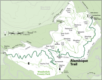
The Alambique Trail is an unpaved service road. It is the only trail in Wunderlich that can take you to Skyline and back without using other trails. It includes two of Wunderlich's five "destination points" - "Alambique Flat" and "The Crossroads", both of which have benches. All loop hikes in lower Wunderlich will involve the Alambique Trail to some extent. The largest known redwood in Wunderlich Park is on this trail on the way up to Alambique Flat - its gnarled limbs and blown out top made it less desirable for milling, which saved it from being felled for lumber.
From main park entrance off Woodside Road, the Alambique Trail starts in the parking lot and heads south past the portable toilet before climbing through a redwood forest for 4.7 miles to Skyline Boulevard. At Skyline Boulevard, you can either head north on the Skyline Trail (Bay Area Ridge Trail) towards Phleger Estates or take a combination of trails (Skyline, Alambique, Oak , Meadow and Alambique again) back to where you started. This wide trail brings you through many different mixed forests as you climb along a comfortable grade for about 1000 feet. You will pass by redwoods, California coffeeberry, California hazelnut, California bay, coast live oak and Douglas fir.
While no trail at Wunderlich provides access to a creek, the Alambique Trail will get you to with-in the sights and sounds of one (depending on time of year and annual rainfall, of course) by visiting the "Alambique Flat." Take a break on the bench and enjoy the sounds…after you catch your breath.
Open to: Equestrian, Hiking
Surface:Gravel, Soil
Length: