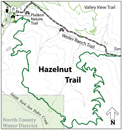
Hazelnut Trail can be accessed directly off of the southern end of the Plaskon Nature Trail in the valley of the South Fork of San Pedro Creek. Perhaps the best trail for viewing the optimal amount of native plants, the Hazelnut Trail takes you through dense vegetation to a height of about 800 feet before descending along a series of switchbacks to the valley of the Middle Fork. As this trail links the valleys of the South and the Middle Forks at a considerable elevation, a variety of sights can be enjoyed such as a deep view of the hidden Montara Mountain side, an impressive oceanic vista, Sweeney Ridge and the expansive valleys of the park.
The trail gently descends into the valley of the Middle Fork of the San Pedro Creek on the eastern reaches of the park where it meets at the end of the Weiler Ranch Road. Weiler Ranch Road will take you back to the parking lot via its leisurely 1-mile stretch along the flat lands of the valley for a total combined loop of about 4.5 miles.
Open to: Equestrian, Hiking
Surface:Soil
Length:
Strenuous
Elevation Change: