Please note: The trails section of the Memorial Park website is currently being updated to reflect changes made to the park trail system. Some of the maps and information below may be incorrect. See our current map or brochure for better information.
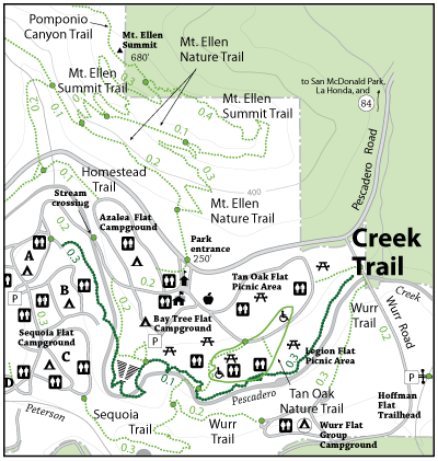
The Creek Trail Starts at the Wurr Road Bridge and continues down to Homestead Flat Youth Campground at the western boarder of Memorial Park. Creek Trail parallels Pescadero Creek taking the hike through a riparian habitat of alders and willows amid the old growth redwoods. Early May through June the hiker is treated to native azaleas in full bloom, while later in the year one can find a number of small waterfalls west of the Campground road, those patient and lucky enough may see steelhead spawning in the riffles. Hikers pass through a number of artificial rock and log structures in the creek. These structures represent an ongoing habitat restoration program undertaken by San Mateo County Parks Department and funded by grants from the Department of Fish and Game. Steelhead and Coho Salmon have declined in many Northern California streams due to logging and mining operations together with poor watershed management practices. Silt and sand from these disturbed areas washed into the streams and decreased the number of steelhead eggs that will hatch and make it harder for the young fish to grow large enough to survive and spawn. These structures increase velocity of the water and channel it so that silt and sand are washed away and create deep pools suitable for habitat.
Open to: Hiking
Surface:Soil
Length:
Easy
Elevation Change: