Please note: The trails section of the Huddart Park website is currently being updated to reflect changes made to the park trail system. Some of the maps and information below may be incorrect. See our current map or brochure for better information.
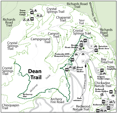
The Dean Trail is a single track trail in the middle of the park. This trail connects to the Crystal Springs Trail, Archery Fire Road and Campground Trail. This trail can be accessed from the Werder Shelter Picnic Area and the Miwok Shelter Picnic Area. A park visitor will encounter various trees such as redwoods, madrone, and oak trees. A park user can stop and eat lunch at a picnic table at McGarvey Flat, where they will also be able to see and hear water in the McGarvey Gulch Creek in the winter.
Open to: Equestrian, Hiking
Surface:Soil
Length:
Moderate
Elevation Change: