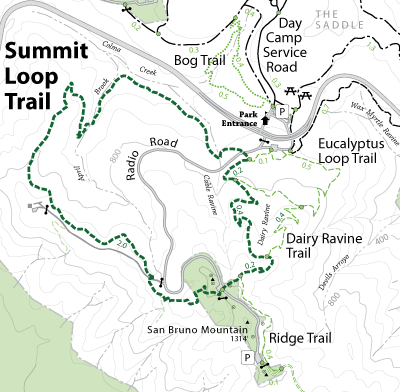
The Summit Loop Trail starts and ends at the Trailhead Parking lot, which is located on the Southeast side of Guadalupe Canyon Parkway, and can only be reached by car from the main park entrance. From the trailhead it is recommended that you begin by hiking west along April Brook where you will enjoy diverse riparian creek side plant communities, and cross three different foot bridges. After the last bridge crossing you start to climb up Bitter Cherry Ridge into savannah grasslands dotted with wild flowers, and coastal scrub. From this point on you will be rewarded by stunning views of the Pacific Ocean and the Peninsula Water Shed, until you reach the summit at 1,314 feet. At the top of the summit you will enjoy panoramic views of the entire Bay Area, which make San Bruno Mountain one of the most unique places to hike in Bay Area. The trail crosses Radio Road and continues eastward, snaking through Kamchatka Rock outcrops, and the junctions of the Dairy Ravine Trail and Eucalyptus Loop Trail.
Open to: Equestrian, Hiking
Surface:Soil
Length:
Strenuous
Elevation Change: